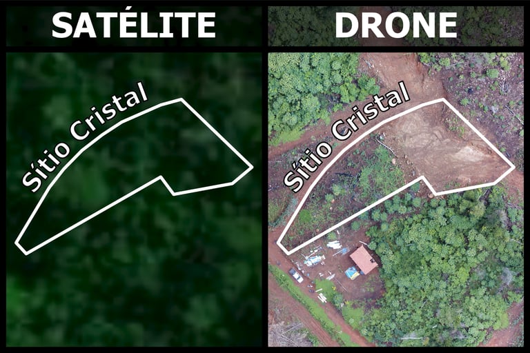
BUT ABOVE?
WHAT IF THE ANSWER ISN'T IN FRONT OF YOU...
NOT ALL PERSPECTIVES ARE GROUNDED
Some answer only appear when we rise above - uncovering patterns, revealing change, and capturing what no spreadsheet or map ever could.
With drone technology, we don't just observe the land - we truly understand it.


SEE WHAT OTHERS CAN'T
Drones reveal mote than landscapes - the reveal insight.
From canopy to contour, uncover what was hidden.
Elevate your view and start making deeper, smarter decisions.


STILL RELYING ON GROUND-LEVEL DATA?
You're not alone - many environmental projects still depend on outdated photos, scattered reports, or incomplete inspections.
But limited views lead to limited understanding.
Manuel work drains time. Errors multiply.
It's time to get above the problem - and see the whole picture.


FLY ABOVE THINK AHEAD
With drones, you move beyond monitoring - you forese.
You mao changesm track recovery, and measure impact from angles the ground can't reach.
Precisions guides your decisions. Aerial data power your strategy.
Welcome to environmental intelligence from above.
WORKING WITH NATURE MEANS SEEING IT COMPLETELY
You've studied the soil, the vegetation — even the water.
Now it's time to unlock a new layer: the sky.
This is your invitation to explore drone-based intelligence — not just as a viewer, but as a practitioner.
We’re handing you the same tools used by environmental professionals, along with real-world results to guide and inspire your next steps.
Whether you're restoring landscapes, monitoring environmental change, or planning with precision — this pack gives you the power to see, process, and act from above.
🧰 The Tools – Delivered to You:
🎁 Trial License of Agisoft – Process your own missions and understand the full workflow
📸 Drone Photos – High-resolution imagery for reports, presentations, and field audits
🖼️ Ortomosaics – Accurate, georeferenced mosaics ready for analysis and mapping
🧠 The Results – Learn by Example:
🌐 Digital Terrain Model (DTM) – See the true ground, stripped of vegetation
🗺️ Digital Surface Model (DSM) – Understand structures and vegetation above the surface
🌀 Contour Lines – Extract slope and elevation for planning and restoration
🧱 3D Models – Visualize terrain with realism, depth, and impact
Each file is processed, optimized, and designed to teach you how drone data becomes insight.
You won’t just observe — you'll learn to replicate professional results with confidence.
$200
FROM
$100
ONLY
🌍 NEED SOMETHING UNIQUE? LET'S BUILD IT!
You know that not every foot fits the same shoe.
So what if your next solution wasn’t out there — but built from your needs?
We believe in tailored Environmental Intelligence — designed for your land, your data, your goals.
Let us know what you need 👉